Live Storm Updates
- inglisbri
- Jan 16, 2022
- 2 min read

Updated: Jan 19, 2022
SUNDAY 9:00
Temperatures rose just above 32 degrees and rain, heavy at times, and wind will persist through the night. This will likely wash away a good portion of the three inches that we have, Snow is still likely on the backside of this system as the low passes to our north for light accumulation in the morning.
SUNDAY 8:00 PM
Freezing rain has begun and the temperature is 30 degrees and rising. How long will below freezing temperatures hold? If they hold for an hour, trees and roads will become iced up. Anything more than an hour and trees and power lines will be at great risk with ice accumulation and the wind.
SUNDAY 7:15 PM
It is 27 degrees and rising as sleet is mixing in with snow. I was just about to call this storm an overachiever if it were to continue snowing for the next hour. I have a total of 3 inches of snow in Westminster. Winds are picking up and conditions could get dangerous if freezing rain persists later on.
SUNDAY 5:30 PM
Heavy Snow en route
It is colder than predicted, winds are picking up and the coastal low is shaping up.
A snow train is forming of heavy bands of snow heading towards central Maryland. These areas could overachieve.

SUNDAY 4:15 PM
Current Radar shows moderate to heavy snow building into the area. Which will last us until the switchover to sleet/freezing rain.

Snowflakes are getting bigger as the column of atmosphere is becoming saturated, and temperatures aloft are warming. This will lead to flakes sticking together and growing bigger until sleet and freezing rain starts around 7-9 PM.
SUNDAY 11:30 AM
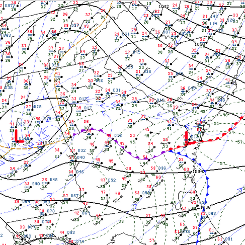
This storm was thought to form a two low system. The stronger one attached to the upper air (more west) and one coastal one (more east). As of now the storm seems to be forming a stronger coastal low than expected. If this persists and the coastal low dominants, we may end up with a more coastal track = colder longer = more snow. This is still a slim possibility, but we shall see how the storm unfolds.
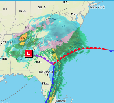
The central low attached to the hip of the upper air is just west of Atlanta however the center of circulation at the surface is just off the coast of Georgia. Will the energy transition into this low? We shall see.


Comments