1/25/2022 - Storm - Pattern Shift
- inglisbri
- Jan 25, 2022
- 1 min read

Updated: Jan 31, 2022
For this post I am trying out something a little different with the format of the post. I hope it is more organized and clearer for you. I will begin the post with a little introduction, then I will list the topics. Each topic can be expanded by clicking on it. Then I will end the post with a little conclusion to wrap up the main points.
For the past few weeks, we have had plenty of cold air diving south but with few organized snow events. We have a good pattern in place, and we are bound to get hit by a major snowstorm at some point along the way. We have had smaller systems and a few clippers come our way, but these carry low impacts. In this post I will go over the current weather weekend storm, and future weather patterns.
CURRENT WEATHER
MAP

Discussion
The boundary of cold air will slowly move into the region bringing cloudy skies and maybe some flurries. Temperatures will drop tonight with clearing skies and temperatures in the teens as high pressure settles in. The boundary of cold air provided from the high pressure will set up across the southern US and up the coast. This will foreshadow the track of the storm this weekend.
WEEKEND STORM
There will be a substantial storm forming up the coast as a cold air trough swings across the eastern part of the country. Where this trough swings, how strong it is, and its dynamics will decide where this storm tracks. As of now, models have the trough swinging up too late, creating a storm that will clip the northeast.
GENERAL STORM TRACK - UPPER AIR
I talk about upper air a lot and how it creates storms and their tracks. It is a good idea to look at 500 mb temperatures to get a good idea of the track and dynamics.
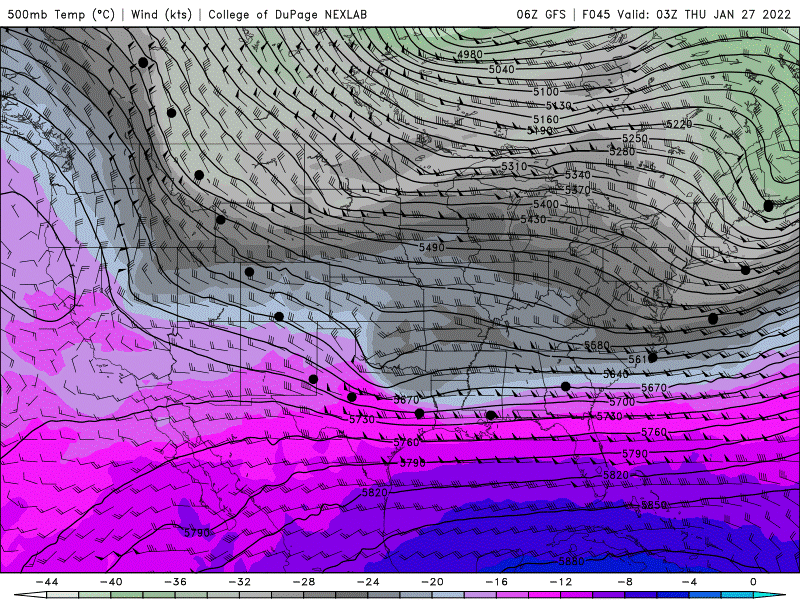
The dots show the general track of the storm's energy. The storm swings down, across, then, up. This is the general motion of an upper-level trough as it swings around the cold air mass center up in Canada. The placement of the cold air mass center in Canada will have the greatest effect on where this storm goes. Then the strength of the trough will determine the smaller changes in track. These latest runs of the GFS have the storm tracking off the coast then north to skip the mid-Atlantic but to affect the northeast. This is just one model.
GENERAL STORM TRACK - VORTICITY
Another way to look at the storms energy and track would be vorticity maps. Vorticity in simplest terms is upper-level energy for storms to feed on. By looking at vorticity you can see where the storm gains its energy from and if and when energy merges.
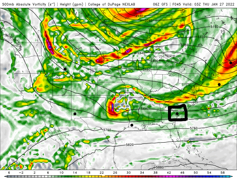
You see the same track as before but now you get insight in its energy; how much it has and where it gets it from. The dot with the box around it is when the system explodes as it gains energy from the trough and pulls northeast. Too far northeast to have any substantial effect on Maryland.
MODEL RUNS AND FUTURE RADAR
Here is the GEM, GFS, then the EURO for Saturday Morning
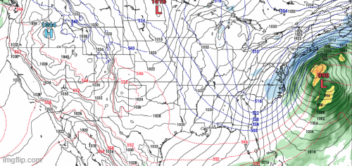
All the models have the storm off the coast forming on the ascending branch of the upper air trough. The European model is most aggressive plot with the strongest storm with a pressure of 971 mb. Moreover, the European model sets up the trough farther west allowing the storm to hug the coast more. We will keep a close eye on this and hope to see more agreement among the models. The fact that they are not in total agreement means this storm's track is not yet decided.
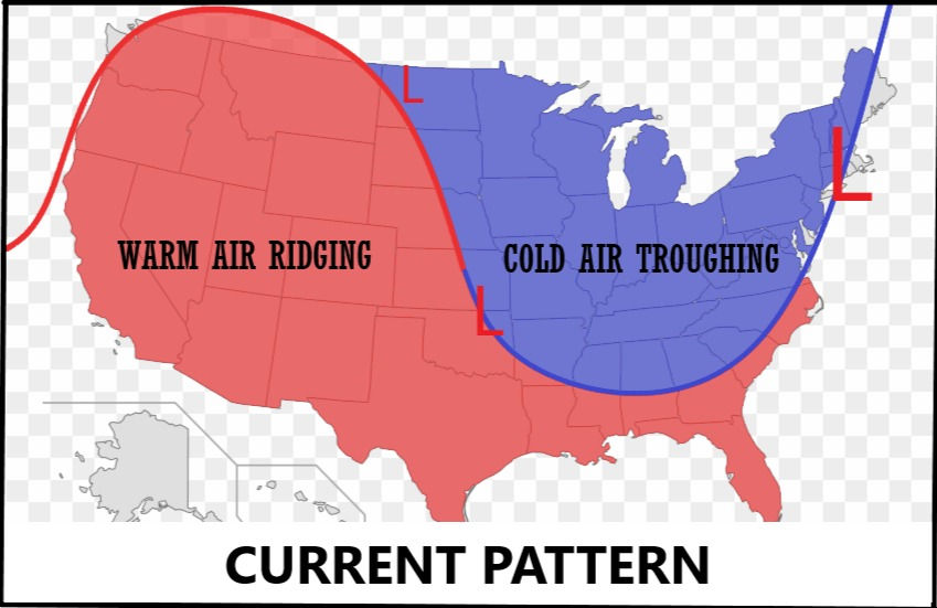
FUTURE WEATHER PATTERN - FEBRUARY
CURRENT PATTERN
I have mentioned it 2 or 3 times before, we are in a cold air pattern where the eastern US gets wave after wave of cold air from Canada.
Here is a general look at this pattern that has been in place the last three weeks or so keeping temperatures cold and brewing up storms. Cold air has been diving south over the eastern portion of the country. The line dividing the two air masses is the jet stream and does fluctuate but this a general representation of its behavior recently.
FUTURE PATTERN
Patterns do not last forever, and I have a feeling that ours is about to change. For those who don't love the cold, there may be light at the end of the tunnel.
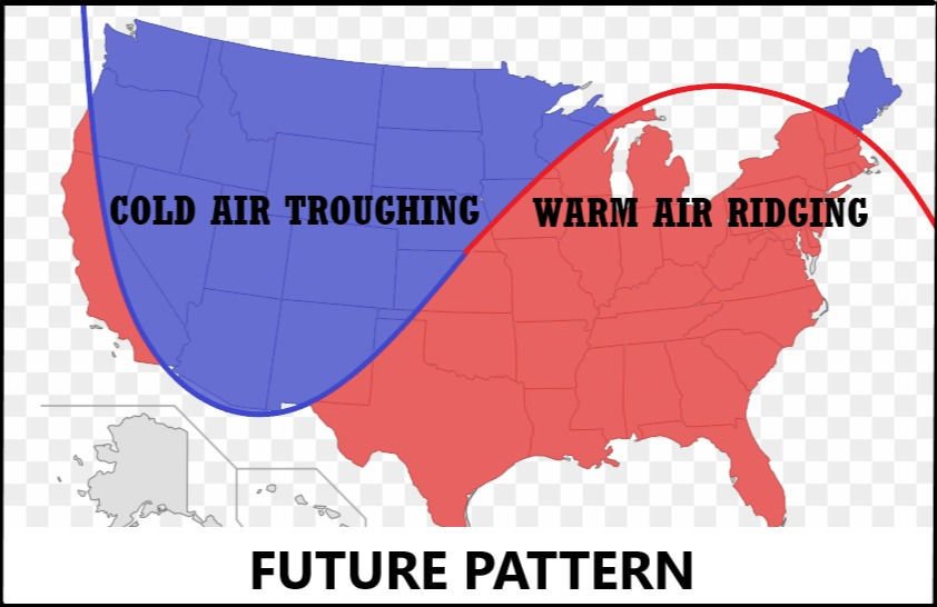
As soon as the first week of February this pattern may take place. The cold dive will shift over the western portion of the country and warm air will rise into the eastern portions. This is still a long way out but modelling larger scale things like huge air masses is easier and more predictable.
Overall, I expect a pattern change. During the first week of February, the Eastern US will start to see warmer temperatures more often. We will still get some cold air, and chances for some storms but they will be less common.


Comments