Weekend Storm - Hold The Hype
- inglisbri
- Jan 2, 2024
- 2 min read

I've been hearing some buzz about a winter storm this coming weekend for Maryland and the rest of the Mid - Atlantic. Here are a few things to remember
The Storm Is Too Far Out
The event is simply too far out to nail down any details. I cannot say for certain if it will be a blockbuster storm or just a few inches. 5 Days is too long. As we get closer to the event there will be increasing certainty however the confidence in the forecast will be dependent on agreement between models and their persistence in their outputs.
General Forecast - What I Do Know
There will be a storm. There will be snow for areas and rain for others. Chances are this will NOT be a major winter storm. However this could be a significant event. Impact will be Saturday into Sunday.
My Take
The set up for this storm is not ideal. Models are not creating a powerful low off the coast and there is not significant circulation of air to 1) create an intense storm with heavy precipitation and 2) draw enough cold air for snow to fall.
I fear that the set up could be weak and will likely lead to a marginal case for significant snow to occur
Here are a few model outputs to highlight the intensity of the storm and corresponding snow amounts. FYI these snow amounts are not to be taken seriously, they are just to show how each set up corresponds to snow accumulation.


Initial Model Rendering - One moderate center of low pressure off the coast with significant circulation - More Cold Air - Stronger Storm - More Snow


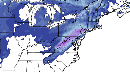
Most recent Model Rendering - Two centers of low pressure - Less concentrated circulation over our area - Less cold air supply - Weaker Storm - Less Snow
Updates will come in the following days


Comments