Snowfall across the area - How'd I do?
- inglisbri
- Jan 6, 2024
- 6 min read

This storm was probably a disappointment for a lot of us, however the system behaved relatively well to what I had expected.
Here is what I forecasted compared to what actually had fallen

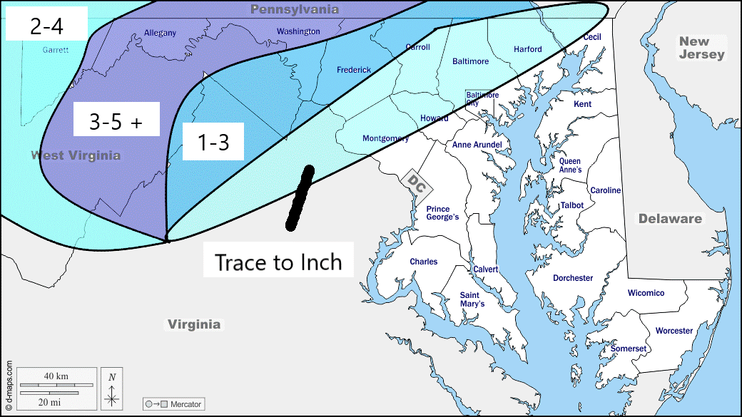
Overall the snow amounts were just a little bit less than what I had expected. Otherwise they were pretty spot on I feel.
Here is a list of the accumulations at towns and cities across, MD, PA, WV and VA to verify that graphic above and for your amusement.
Ski Liberty saw around 5.5 inches of Snow!
Taneytown saw 2 inches
Areas around Baltimore saw little to no snow :(
MARYLAND

...Allegany County...
  Cumberland              7.0   431 PM  1/06  Trained Spotter
  Ridgeley 1 NW           6.6   439 PM  1/06  Trained Spotter
  Potomac Park 2 NW       6.5   352 PM  1/06  Trained Spotter
  La Vale 1 E             6.0   402 PM  1/06  Trained Spotter
  Frostburg 2 ENE         6.0   545 PM  1/06  Trained Spotter
  La Vale 1 S             6.0   524 PM  1/06  Trained Spotter
  La Vale                 6.0   413 PM  1/06  Dept of Highways
  Brady 1 SW              6.0   514 PM  1/06  Trained Spotter
  Frostburg  NW           6.0   536 PM  1/06  Trained Spotter
  Cumberland 1 SSE        6.0   500 PM  1/06  Trained Spotter
  Cresaptown  SSW         5.5   300 PM  1/06  Trained Spotter
  Wolfe Mill 2 NNE        5.3   247 PM  1/06  Trained Spotter
  Frostburg               5.0   417 PM  1/06  Trained Spotter

...Anne Arundel County...
  Eastport 1 S            0.2   131 PM  1/06  Trained Spotter
  Bwi Airport               T   100 PM  1/06  Official NWS Obs

...Baltimore County...
  Reisterstown 1 NW       0.4   500 PM  1/06  CoCoRaHS
  Reistertown 2 NW        0.1  1259 PM  1/06  Co-Op Observer

...Baltimore City...
  Pikesville 3 SE         0.2  1135 AM  1/06  Trained Spotter

...Carroll County...
  Taneytown  NE           2.0   200 PM  1/06  Trained Spotter
  Uniontown 3 N           0.5  1247 PM  1/06  Trained Spotter
  Westminster             0.3  1230 PM  1/06  Trained Spotter

...Frederick County...
  Thurmont  NW            4.0   548 PM  1/06  Public
  Thurmont 1 SSE          1.5   145 PM  1/06  Trained Spotter
  Bloomfield 2 WSW        1.2   130 PM  1/06  NWS Employee
  Braddock Heights 2 N    1.1   152 PM  1/06  Trained Spotter
  Ballenger Creek  WSW    0.2   130 PM  1/06  Trained Spotter

...Garrett County...
  Grantsville 3 E         6.0   723 PM  1/06  Trained Spotter
  Frostburg 3 WNW         6.0   405 PM  1/06  Trained Spotter
  Barton                  4.0   400 PM  1/06  Public
  Accident 4 E            3.8   401 PM  1/06  Public
  Oakland                 3.5   404 PM  1/06  Dept of Highways
  Grantsville 5 W         3.0   300 PM  1/06  Dept of Highways
  Deer Park 6 NE          2.5   115 PM  1/06  Trained Spotter
  Mc Henry 4 SE           1.8   355 PM  1/06  Park/Forest Srvc
  Grantsville 7 WNW       1.0   325 PM  1/06  Trained Spotter

...Harford County...
  Norrisville 1 WSW       0.7  1130 AM  1/06  CoCoRaHS
  Churchville 1 N         0.2   121 PM  1/06  Trained Spotter
  Abingdon 1 NW             T   325 PM  1/06  Trained Spotter

...Montgomery County...
  Damascus 3 SSW          0.2   100 PM  1/06  Co-Op Observer
  Laytonsville 2 WNW        T   123 PM  1/06  Trained Spotter

...Washington County...
  Pecktonville 3 NNW      6.1   448 PM  1/06  NWS Employee
  Hancock 1 ESE           5.5   530 PM  1/06  Trained Spotter
  Clear Spring            5.0   559 PM  1/06  Trained Spotter
  Leitersburg             4.5   614 PM  1/06  Trained Spotter
  Fort Ritchie            4.5   513 PM  1/06  Trained Spotter
  Long Meadow 2 WNW       4.3   300 PM  1/06  Trained Spotter
  Boonsboro 3 NNE         3.7   530 PM  1/06  Trained Spotter
  Fairplay 3 ENE          2.5   300 PM  1/06  Trained Spotter
  Hancock                 1.5  1145 AM  1/06  NWS Employee

VIRGINIA

...Arlington County...
  Reagan National Apt       T   100 PM  1/06  Official NWS Obs

...Culpeper County...
  Cardova 2 NW              T   535 PM  1/06  Trained Spotter

...Fairfax County...
  Centreville               T   845 PM  1/06  Trained Spotter

...Frederick County...
  Cedar Hill 4 NNW        3.1   655 PM  1/06  Trained Spotter
  Winchester              1.3   600 PM  1/06  Trained Spotter
  Stephens City 2 E       1.2   417 PM  1/06  Trained Spotter
  Stephens City           1.1   506 PM  1/06  Trained Spotter
  Winchester 3 E          0.5  1250 PM  1/06  Public

...Highland County...
  Hightown 5 NW           7.0   332 PM  1/06  Public
  Hightown 4 NW           6.0   334 PM  1/06  Dept of Highways
  Monterey                5.0   340 PM  1/06  Dept of Highways

...Loudoun County...
  Bluemont                0.8   444 PM  1/06  Dept of Highways
  Bloomery 3 ESE          0.8   445 PM  1/06  Trained Spotter
  Harpers Ferry 10 S      0.5  1208 PM  1/06  Trained Spotter
  Hillsboro 3 NE          0.5   200 PM  1/06  Trained Spotter
  Purcellville            0.2   108 PM  1/06  Co-Op Observer
  Purcellville 2 E        0.1   211 PM  1/06  NWS Employee
  Dulles International      T   100 PM  1/06  Official NWS Obs

...Page County...
  Rileyville 1 W          0.5   233 PM  1/06  Trained Spotter

...Prince William County...
  Woolsey 1 SW              T  1215 PM  1/06  Trained Spotter

...Rockingham County...
  Timberville 3 NW        0.8   500 PM  1/06  Trained Spotter

...Warren County...
  Karo 1 WSW              0.5   630 PM  1/06  Trained Spotter
  Riverton 1 WNW          0.5   415 PM  1/06  Trained Spotter

WEST VIRGINIA

...Berkeley County...
  Falling Waters          5.5   555 PM  1/06  Trained Spotter
  Martinsburg             5.0   558 PM  1/06  Trained Spotter
  Falling Waters 2 NW     4.8   433 PM  1/06  Trained Spotter
  Martinsburg 2 E         4.0   413 PM  1/06  NWS Employee
  Martinsburg  NW         3.5   342 PM  1/06  Public
  Inwood 2 W              3.0   519 PM  1/06  Trained Spotter
  Glengary                2.0   110 PM  1/06  Public
  Shepherdstown 4 NNW     2.0   100 PM  1/06  Trained Spotter

...Grant County...
  Cabins                  6.8   521 PM  1/06  Trained Spotter
  Maysville               6.0   516 PM  1/06  Trained Spotter
  Mount Storm             5.5   356 PM  1/06  Dept of Highways
  Petersburg              4.0   350 PM  1/06  Dept of Highways
  Bayard                  1.0   320 PM  1/06  Co-Op Observer

...Hampshire County...
  Oldtown 2 S             6.0   502 PM  1/06  Trained Spotter
  Springfield             6.0   738 PM  1/06  Trained Spotter
  Lehew 3 W               5.5   540 PM  1/06  Trained Spotter
  Romney                  5.3   230 PM  1/06  Trained Spotter

...Hardy County...
  McNeill 3 NNW           5.5   541 PM  1/06  Trained Spotter
  Moorefield 2 N          5.5   300 PM  1/06  Trained Spotter
  Rig  NNW                5.4   445 PM  1/06  Trained Spotter
  Fisher 4 SE             4.5   606 PM  1/06  Trained Spotter
  Wardensville 3 E        4.0   423 PM  1/06  Trained Spotter
  Moorefield 4 SSE        4.0   530 PM  1/06  Trained Spotter

...Jefferson County...
  Shepherdstown           4.0   517 PM  1/06  Trained Spotter
  Harpers Ferry           0.5   553 PM  1/06  Trained Spotter
  Bloomery 3 SSE          0.5  1245 PM  1/06  Trained Spotter
  Shepherdstown 1 NW        T   306 PM  1/06  Trained Spotter

...Mineral County...
  Keyser 2 SSW            6.8   450 PM  1/06  Co-Op Observer
  Patterson Creek         6.0   520 PM  1/06  Trained Spotter
  Keyser                  6.0   359 PM  1/06  Trained Spotter
  Burlington  E           5.1   345 PM  1/06  Trained Spotter
  Russelldale 3 NNE       2.0  1215 PM  1/06  Trained Spotter

...Morgan County...
  Berkeley Spgs           5.0   535 PM  1/06  Trained Spotter

...Pendleton County...
  Ruddle 3 NW             6.0   523 PM  1/06  Trained Spotter
  Deer Run 2 WSW          5.5   344 PM  1/06  Trained Spotter
  Franklin 1 W            5.5   400 PM  1/06  County Emergy Mgmt
  Seneca Rocks            4.0   337 PM  1/06  Public
  Franklin 1 SW           2.5  1212 PM  1/06  Trained Spotter


**********************24 HOUR SNOWFALL**********************

LOCATION              24 HOUR      TIME/DATE  COMMENTS
                     SNOWFALL       MEASURED
                     (inches)

MARYLAND

...Baltimore County...
  Reisterstown 1 NW       0.4   500 PM  1/06  CoCoRaHS

...Montgomery County...
  Damascus 3 SSW          0.2   100 PM  1/06  Co-Op Observer


**********************STORM TOTAL ICE***********************

LOCATION                TOTAL      TIME/DATE  COMMENTS
                          ICE       MEASURED
                     (inches)

MARYLAND

...Allegany County...
  La Vale 1 S               T   524 PM  1/06  Trained Spotter

...Baltimore County...
  Bentley Springs        0.05   150 PM  1/06  Dept of Highways

...Frederick County...
  Ballenger Creek  WSW   0.10   130 PM  1/06  Trained Spotter
  Adamstown 1 ESE        0.09   300 PM  1/06  NWS Employee

...Garrett County...
  Grantsville 7 WNW         T   325 PM  1/06  Trained Spotter

...Harford County...
  Norrisville            0.05   453 PM  1/06  Trained Spotter
  Abingdon 1 NW             T   325 PM  1/06  Trained Spotter

VIRGINIA

...Albemarle County...
  Charlottesville        0.01  1200 PM  1/06  Broadcast Media

...Clarke County...
  Paris 1 NW             0.10   443 PM  1/06  Dept of Highways

...Culpeper County...
  Cardova 2 NW           0.01   535 PM  1/06  Trained Spotter

...Frederick County...
  Winchester             0.10   601 PM  1/06  Trained Spotter
  Cedar Hill 4 NNW          T   655 PM  1/06  Trained Spotter

...Loudoun County...
  Bluemont               0.10   445 PM  1/06  Dept of Highways
  Bloomery 3 ESE         0.10   445 PM  1/06  Trained Spotter

...Nelson County...
  Wintergreen 1 NW       0.25   420 PM  1/06  Law Enforcement

...Page County...
  Rileyville 1 W         0.06   233 PM  1/06  Trained Spotter

...Rockingham County...
  Dale Enterprise 1 ES   0.20   630 PM  1/06  Trained Spotter
  Timberville 3 NW       0.08   500 PM  1/06  Trained Spotter

...Warren County...
  Riverton 1 WNW         0.06   415 PM  1/06  Trained Spotter
  Karo 1 WSW             0.06   630 PM  1/06  Trained Spotter

WEST VIRGINIA

...Berkeley County...
  Martinsburg 2 E           T   413 PM  1/06  NWS Employee

...Hardy County...
  Moorefield 4 SSE          T   530 PM  1/06  Trained Spotter

...Jefferson County...
  Shepherdstown 1 NW        T   306 PM  1/06  Trained Spotter
I will also mention that the storm switched to freezing rain or rain at an earlier time than I hard forecasted for the general Carroll County area. It had switched around 1:15 PM when I had thought it would sleet till 4 and switch to rain then. This mistake lead to a slight overestimate in my snowfall forecast.


Comments