Lengthy Storm then Cold Over the Weekend
- inglisbri
- Feb 2, 2022
- 1 min read

We will experience a roller coaster of weather the next few days as a cold front moves down and across the country clearing our area by Friday.
CURRENT WEATHER

The cold front in the center of the picture is the boundary of a large piece of cold upper air. Behind this turbulent boundary, rain changes to freezing rain then snow and ahead of the boundary, warm temperatures bring about a soaking rain. This disturbance will organize into a surface and slowly move east to affect our weather Thursday into the weekend.
THE STORM
This storm will be slow moving and will have two faces; a mild rain and a freezing rain. Its first face will bring about a warm influx of air and rain will fall Thursday ahead of the front. These warming temperatures have the potential to drop viciously sometime Friday depending on the timing of the front. Icy conditions could be prevalent for the majority of Maryland Friday into Saturday. Overall, timing is key with this storm. If the cold moves in before or around sunrise, it will settle in and hold throughout the day leading to freezing rain and flash freeze. However, if it lags behind, it will have missed its window, eliminating freezing rain and pushing off any freezing till afternoon - sunset. Schools will have to make yet another tough call that could be useful or useless.
Timeline
NAM Model - Day and Time is in the top left - 12z = 7am
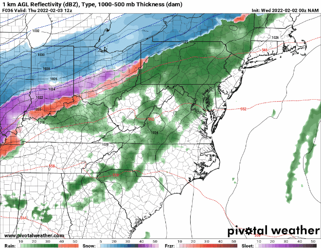
Rain ahead of the front begins Wednesday night and could get spotty throughout the day on Thursday.
Rain associated with the front moves in Thursday night as cold air rushes behind it. I do expect some changeover to freezing rain/sleet in the northern counties between 5 am and 9 am. This is the window for things to get really icy and dangerous.
Precipitation will taper off in the afternoon as some flurries.
Even if temperatures don't fall below freezing in the morning, expect freezing to occur after the event, overnight as temperatures sink.
Temperatures
11 PM vs 5 AM
Temperatures could drop below freezing by 5 AM for some regions allowing for freezing rain to develop.

Temperatures will be marginal for this event and temperatures would have to drop from the forties/fifties to below freezing in a short amount of time. Areas kept cooler ahead of the event by cold air damming have the shortest amount of cooling to occur when the front pushes through and will be the most likely for freezing rain.
Timing is everything. If this cold front moves in before or around sunrise, temperatures in those areas could settle in below freezing for the day. If it moves in later, we will feel colder, but won't break freezing till late afternoon. The cold front will come from the northwest and cold air will overtake from the northwest to the southeast.
Forecast
Here is the forecast showing the chances for impactful freezing rain. This forecast is based on two things: when the cold front moves in and how warm temperatures get ahead of the cold front. These two factors will determine how quickly or slowly temperatures drop below freezing.

Areas most north will have the cold air settle in before sunrise, keeping temperatures below freezing the whole day. This gives them a great chance to see impactful freezing rain. Up to a quarter inch of ice could accumulate on any surface making travel dangerous. Temperatures will drop from the mid-thirties to below freezing easily. Deep freeze by 3 PM.
In the 50/50 region, temperatures could be kept cool in the upper thirties ahead of the front via cold air damming. Because of this, these areas could drop below freezing by Friday morning when the front passes through. Up to a tenth of ice could accumulate on raised surfaces, trees, powerlines and some roads leading to potentially dangerous travel. Any weakening of cold air damming or a later passage of the front could keep temperatures above freezing till late afternoon, this is why this area is called 50/50. Deep freeze by 5 PM.
The improbable areas will see warm temperatures overnight and the front will move in late morning for this region. It will take till afternoon for most of these areas to get below freezing. Freezing rain is possible and will likely happen at some point but will not be impactful. Deep freeze overnight.
Determining Factor?
The orientation and strength of the low pressure that forms along this front will determine how temperatures act during this storm. These charaterictics of the storm didnt change much, but a subtle change can make all the difference.
Yesterday's GFS run for Thursday at 10 PM

Initially, a weaker, flat system would form along a cold front falling south into our region. This would bring less warm air into Maryland and a faster moving cold front. You can see the boundary between cold and warm air in the dotted purple in northern Maryland at a somewhat of a flat angle.
Today's GFS run for Thursday at 10 PM

This newer run shows a stronger more northern center of low pressure. This would bring a stronger influx of warm air reaching areas of southern PA. You can now see that not only is the boundary between cold and warm air further north, it is also tilted more vertically. This really shows how a stronger low pressure has more circulation and brings in more warm air.
These fresher model runs show a change in the make up of the storm. Initally precipitation was forming off an advancing cold front. Now, with a stronger surface low, precipitation is forming as warm air overshooting cold air. This change, could significantly lower chances for freezing rain in Maryland.
Final Notes
Predicting these types of storms is so tough because temperatures at the surface and above are so marginal. Moreover, these is a huge temperature gradient. It could be in the fifties in one area and 50 miles northwest it could be in the thirties. The setup of this warm air ahead of the storm and where cold air damming sets up will define who gets below freezing fastest.
With that said, it is best to forecast the timing of switchover and freezing rain as we go along with the event. Thursday night around 1 AM will be peak warmth, at this point we can see how realistic it will be for temperatures to drop below freezing by sunrise.
If warm air overachieves Thursday night OR if the front moves in after sunrise, freezing rain will be less widespread Friday morning
Perhaps we should look to the Jan 20th storm for guidance. This storm began with rain and cold air was plotted to settle in before sunrise, however warm air lingered longer and when the cold air moved in after sunrise it couldn't settle in below freezing for the day. Temperatures didn't fall below freezing until afternoon - night. I have a feeling this scenario could happen again for this storm; models tend to overestimate how fast cold air moves in.
Comments