Fresh Look at The Storm
- inglisbri
- Jan 26, 2022
- 1 min read

Over the last few days, it seemed the storm was really shaping up. With cold air in place, and other pieces setting up, it seemed the storm would ride up along the coast, strengthen, and dump snow along coastal and some interior regions. The model runs were consistent and worth believing but now as the event gets closer, the models have a slightly different take on the storm. However, I take this with a grain of salt. This storm is very unique in how it forms, and it could negatively affect how accurate model guidance is up until its formation.
HOW THIS STORM FORMS
AT THE SURFACE
Most storms trek across the entire country and can be seen on satellite as soon as five days out from the event. This storm, however, forms the day of the event, Friday, as it seems to form out of nowhere off coast of the Carolinas. This will lead to some uncertainty in the forecast.
On Thursday there is no surface low or even much precipitation around or off the coast of Florida/Georgia. But on Friday, the storm forms and explodes up the coast. So much happens in such a short amount of time and a lot is riding on the initial formation of the storm. Once this happens, we can hone in on the storm track.
AT THE UPPER AIR LEVEL
Now this storm might seem to appear out of nowhere, while really its energy does not. Its energy from the upper-level trough can be seen tracking across the country and up the coast. This energy is what guides the storm and lays out a general storm track.
Upper Air Temps - Dots show track of energy
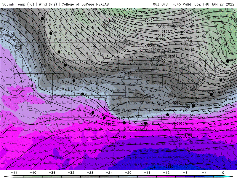
This model run from yesterday and the current model runs of upper air temps are very similar. It has the storm tracking north a couple of hundred miles of the coast. This would take the brunt of the snow away from central Maryland. Some prior runs have the energy swinging north earlier, bringing a more coastal track, which I will have to keep an eye out for.
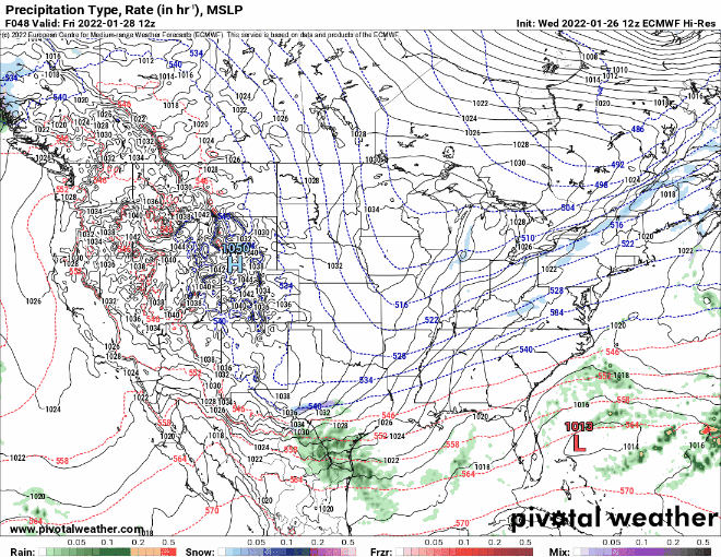
STORM TRACK AND EFFECTS
Current Model Runs
Here are the current model runs for 6 AM SATURDAY with the name of each model in the top right. I want you to pay attention to the position of the low pressure, L, and the position and orientation/tilt of the dotted blue line which show the upper-level air temperatures and boundaries. Where this cold air and its boundary sets up determines how close or far the storm tracks.

In just about all the models Maryland is on the verge of snow. With coastal areas getting more. As you can see there is still considerable variation in the set up of the cold air trough and the resulting track of the storm.
What affects the track?
The position and orientation of the trough decides storm track. Right now, we are looking at upper-level trough setting up over the eastern part of the country. This is good for a storm to travel north up the coast. How far west or east this trough is positioned will determine how far west or east the storm tracks. Moreover, if the trough is titled a certain way, that will determine if the storm pulls back or away from the coast as it is pulling north.
Here is a look at the upper air trough in the colored image and the surface weather in the white image with precipitation.

Right now, the trough is positioned in a good spot, designated by the dotted blue lines with cold air behind it. However, the cold air trough is tilted positively or slightly towards the right, this will favor a storm track that goes off into the ocean rather than hugging the coast. If the cold air were oriented so it is tilted to the left, or negatively, then the storm would follow suit, and hug the coast bringing a strong storm.
In order for a more westward negatively tilted trough, we would need the cold air center at the top of image in Canada to be further west, so the trough can swing north earlier. This would cause the high pressure over the center of the country to set up further west which would bring the cold air trough further west along with the resulting storm track being more coastal.
Storm Probabilities and Snowfall
Areas will likely get a coating to an inch of snow on Friday night ahead the storm. As of now I believe the storm will track off the coast far enough so that most of Maryland will miss the brunt of the snowfall on Saturday. I feel 95 will be the general cut-off line for Saturday snow. With areas along this line getting 1-3 inches and areas east of this line having potential to score more if the track holds.
The storm has two days to even form, and models are wobbling the storm track. Nothing is set in stone and things can and will change.

Comments